OSM Water Layer
Surface Waters in OpenStreetMap (Global)
OSM Water Layer is a global surface water dataset generated by extracting water-related features from OpenStreetMap (OSM).
Both filtered OSM data (PBF) and rasterized maps (GeoTIFF) are available.
Data Summary
We extracted surface waters from the OpenStreetMap planet.pbf archive:
OpenStreetMap Planet data.
Water-related features were extracted using the following OSM tags:
natural=waterwaterway=*landuse=reservoir
A raster surface water map was generated at 3 arc-second resolution (~90 m at the equator).
For rasterization, surface waters are classified into four categories:
- Large Lake & River: surface water represented as Polygon
- Major River:
waterway=riverbank, river - Canal:
waterway=canal, drain - Minor Stream:
waterway=ditch, stream, brook, wadi, drystream
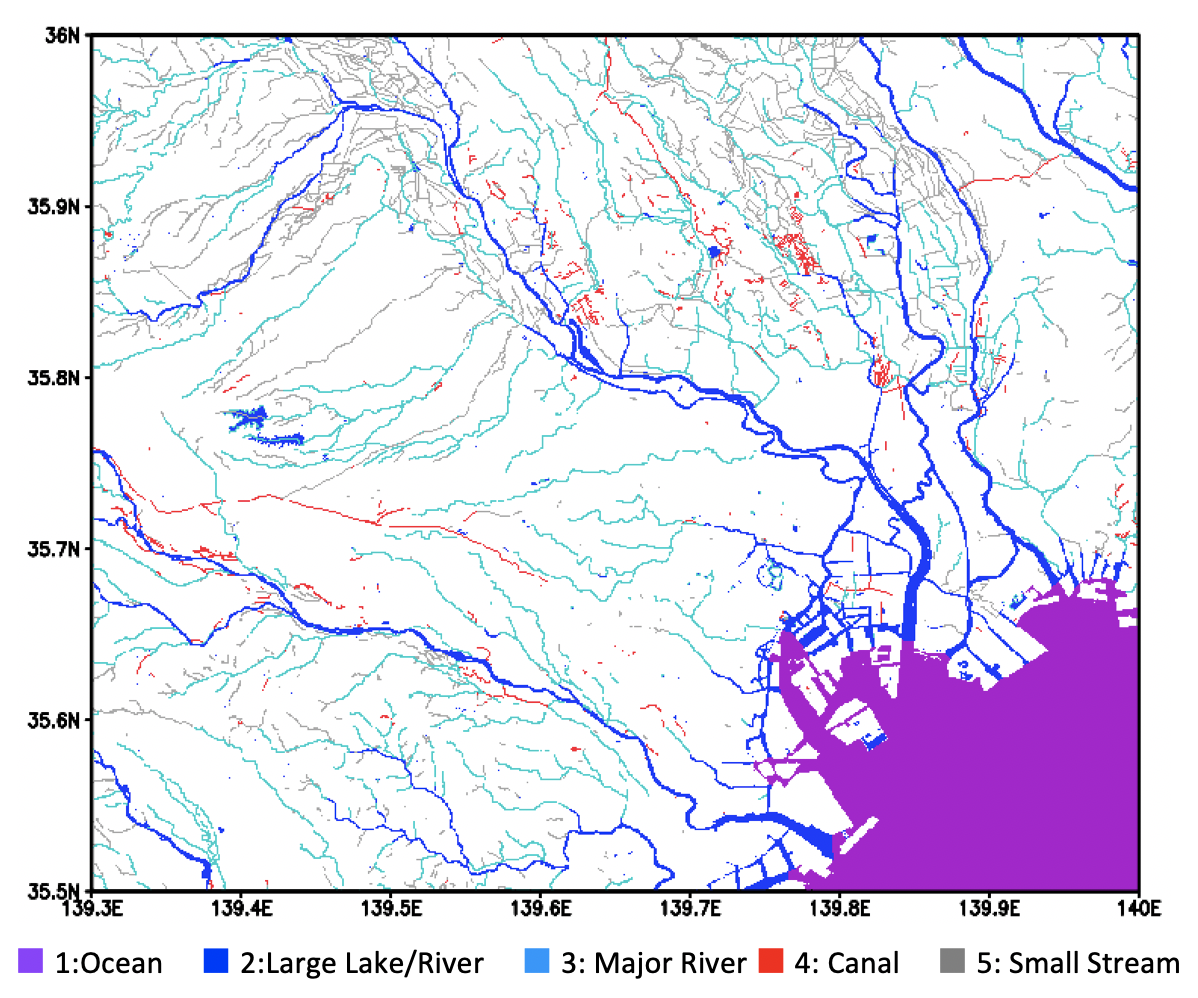
Rasterized surface water map: Tokyo, Japan
Data Description
Global vector database (PBF)
The global vector database is prepared in OpenStreetMap PBF format and can be handled by OSMOSIS.
Rasterized GeoTIFF map
- CRS: WGS84
- Tiling: 5° × 5° tiles (6000 × 6000 pixels each)
- Filename convention: the filename represents the center of the lower-left pixel.
Example:n30w120.tifcovers N30–N35, W120–W115 (more accurately: N29.99958333–N34.99958333, W120.0004167–W115.0004167). - The 5° tiles are also distributed as one global tar.gz archive.
Note: High resolution version for Japan is also available.
User Registration (Optional)
Registration is not mandatory, but we would like to know who is using OSM Water Layer and for what applications.
If you don’t mind, please register via the Google Form below. Update notices will be sent when a new version is released.
Data Download
Latest version: ver 2.0 (based on planet.osm.pbf as of 12 Feb 2021)
Please access to the DropBopx to download OSM Water Layer products.
OSM WaterLayer download page (DropBox)
Global vector database (PBF)
OSM_WaterLayer.pbf
License: OdBL 1.0 (summary)
By downloading and using the data, the user agrees to the terms and conditions of the license.
Rasterized GeoTIFF map (tar.gz)
OSM_WaterLayer_tif
License: CC BY 4.0
By downloading and using the data, the user agrees to the terms and conditions of the license.
Open-source code on GitHub
The code/scripts to generate OSM Water Layer are publicly available:
global-hydrodynamics/OSM_WaterLayer
Old version archive
Version 2 (based on the latest OSM data as of 12 Feb 2021)
- The scripts used to generate OSM Water Layer are available on GitHub:
global-hydrodynamics/OSM_WaterLayer
Version 1 (based on planet.osm.pbf as of 16 Jan 2018)
- Available in DropBox.
Contact
Dai YAMAZAKI, Institute of Industrial Sciences, The University of Tokyo
yamadai [at] iis.u-tokyo.ac.jp