G3WBM / G1WBM
Global 3-second / 1-second Water Body Map
The Global 3 arc-second Water Body Map (G3WBM) and the 1 arc-second version (G1WBM) are global surface water datasets developed using multi-temporal Landsat imagery from the Global Land Survey (GLS) archive.
The datasets distinguish permanent water bodies from temporally inundated areas by analyzing water occurrence frequency across overlapping Landsat scenes.
Dataset Overview
- Resolution:
- 3 arc-second (~90 m) – G3WBM
- 1 arc-second (~30 m) – G1WBM
- Derived from: Multi-temporal Landsat GLS archive (33,890 scenes across 4 epochs)
- Seamless global coverage without cloud/snow gaps
- Clear separation of river channels and floodplains based on water frequency analysis
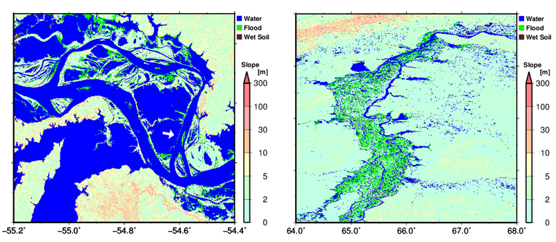
Example: Amazon floodplain and Ob River
Data Description
File Format
- GeoTIFF
- 5° × 5° tiles
- Filename represents the center of the lower-left pixel
Example:n30w120_wat.tifcovers N30–N35, W120–W115 - Tiles are distributed in 30° × 30° compressed packages (.tar)
Classification Scheme
| Value | Description |
|---|---|
| 0 | Land |
| 1 | Land (No Landsat observation) |
| 10 | Snow |
| 20 | Wet soil / Wet vegetation / Lava |
| 30 | Salt marsh |
| 40 | Temporal flooded area |
| 50 | Permanent water |
| 51 | Permanent water (added by SWBD) |
| 99 | Ocean |
Reference Paper
Please cite the following paper when using G3WBM/G1WBM:
Yamazaki, D., Trigg, M., & Ikeshima, D. (2015)
Development of a global ~90 m water body map using multi-temporal Landsat images
Remote Sensing of Environment
https://dx.doi.org/10.1016/j.rse.2015.10.014
Citation of the paper is sufficient for general dataset use.
If substantial additional support or processing is provided, acknowledgement or co-authorship may be requested.
Download G3WBM/G1WBM
How to obtain the data
- Register via the Google Form (license agreement)
- Receive the password by email
- Access the download page.
Registration (Required)
Please register to obtain access:
Alternatively, contact:
yamadai [at] iis.u-tokyo.ac.jp
Download (Password Required)
All datasets are distributed via Dropbox (password protected):
G3WBM/G1WBM Dropbox Download Folder
Available products:
- G3WBM ver 1.3 (GeoTIFF tiles, packaged by 30° × 30°)
- G1WBM ver 1.0 (GeoTIFF tiles, packaged by 30° × 30°)
License
G3WBM/G1WBM is licensed under:
Creative Commons Attribution 4.0 International (CC-BY 4.0)
License details
By downloading and using the data, users agree to the terms of this license.
We kindly ask users not to redistribute the complete dataset in its original format on other websites without written permission from the authors.
Version Information
G3WBM
- Current Version: ver 1.3 (20 March 2018)
- ver1.1: Improved river–ocean boundary
- ver1.2: Bug fix around river mouths
- ver1.3: Grid coordination fix; license changed to CC-BY 4.0
G1WBM
- Current Version: ver 1.0 (20 March 2018)
- First release of 1 arc-second version
Contact
Institute of Industrial Sciences
The University of Tokyo
yamadai [at] iis.u-tokyo.ac.jp